Loading...
Changeset: 77558
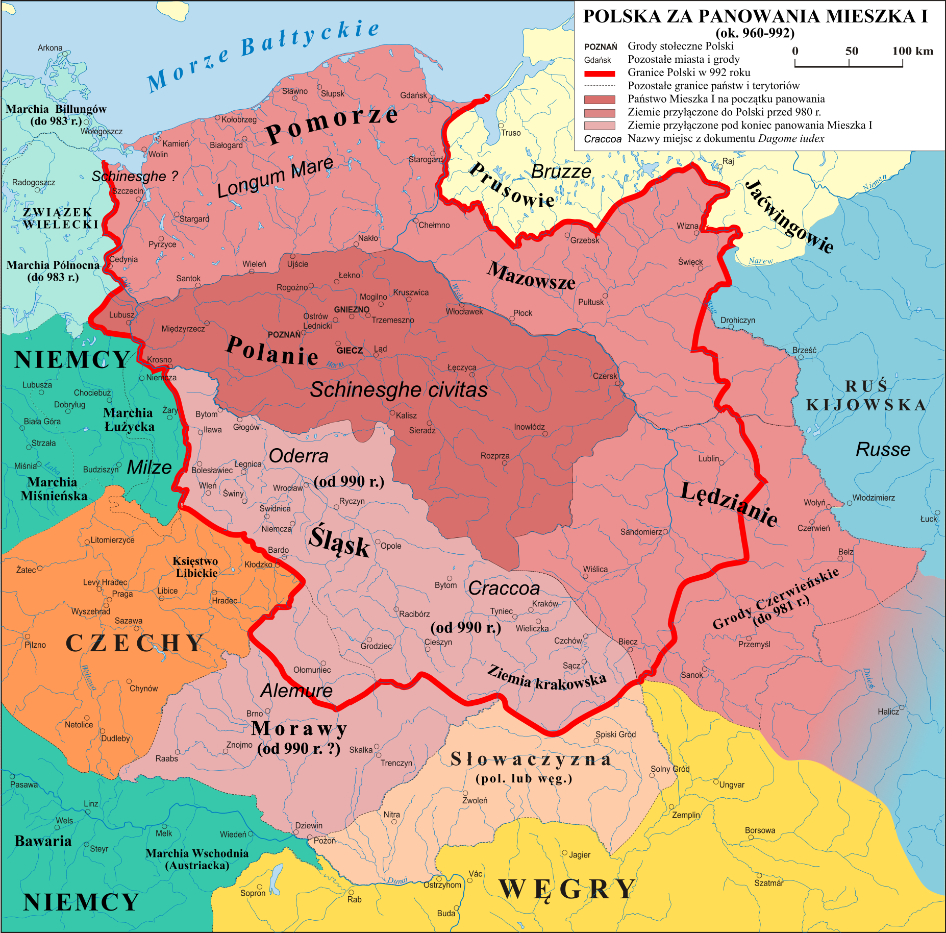
Started mapping borders of Duchy of Poland (973-981)
Closed by Alanantos
Tags
| changesets_count | 21 |
|---|---|
| created_by | iD 2.24.1 |
| host | https://www.openhistoricalmap.org/edit |
| imagery_used | Geoportal 2: Orthophotomap (latest aerial imagery) (WMTS);Bing Maps Aerial |
| locale | en-GB |
| resolved:crossing_ways:railway-waterway | 1 |
| source | https://upload.wikimedia.org/wikipedia/commons/c/c8/Polska_960_-_992.png |
| warnings:crossing_ways:railway-waterway | 13 |
Discussion
Ways (1-20 of 22)
- 1
- 2
- Дністер (24392145), v47
169961074, v2169961079, v2169961081, v3- Дністер (181471324), v2
- 198556348, v2
- 198556577, v4
- 198592367, v3
- 198722625, v2
- 199383267, v2
- 199480332, v1
- 199480333, v1
- 199480334, v1
- 199480335, v1
- 199480336, v1
- 199480337, v1
- 199480338, v1
- 199480339, v1
- 199480340, v1
- Дністер (199480341), v1
Relations (21-40 of 44)
- 2693975, v29
- Hungary (1860-1867) (2694212), v7
- Hungary (1849-1860) (2694213), v15
- Украинская ССР (1954—1991) (2694779), v26
- Украина (1991) (2694780), v26
- Україна (2014-) (2694805), v23
- Украинская ССР (1951—1954) (2694806), v23
- Украинская ССР (1948—1951) (2694807), v22
- Украинская ССР (1945—1948) (2694811), v25
- województwo podkarpackie (2003-) (2695615), v6
- województwo podkarpackie (1999-2003) (2695691), v5
- Kingdom of Poland (1569-1772) (2696309), v18
- 2696431, v3
- Deutsches Reich (1940-1941) (2704713), v16
- Deutsches Reich (1940 06-08) (2704714), v18
- Deutsches Reich (1940 05-06) (2704715), v19
- Deutsches Reich (1939-1940) (2704716), v18
- Deutsches Reich (1941 04-08) (2704717), v15
- Deutsches Reich (1939-1941) (2704718), v16
- Księstwo Polskie (960-973) (2740036), v8
Nodes (1-20 of 852)
Welcome to OpenHistoricalMap!
OpenHistoricalMap is an interactive map of the world throughout history, created by people like you and dedicated to the public domain.
OpenHistoricalMap is a charter project of OpenStreetMap U.S., a 501(c)(3) nonprofit organization affiliated with the OpenStreetMap Foundation. Technical development is supported by GreenInfo Network and Development Seed.
| https://openstreetmap.org/copyright | https://openstreetmap.org |
| Copyright OpenHistoricalMap and contributors, under an open license | |