Loading...
Changeset: 77569
Started mapping borders of Duchy of Poland (973-981) - east
Closed by Alanantos
Tags
| changesets_count | 22 |
|---|---|
| created_by | iD 2.24.1 |
| host | https://www.openhistoricalmap.org/edit |
| imagery_used | Geoportal 2: Orthophotomap (latest aerial imagery) (WMTS);Bing Maps Aerial |
| locale | en-GB |
| resolved:missing_tag:any | 1 |
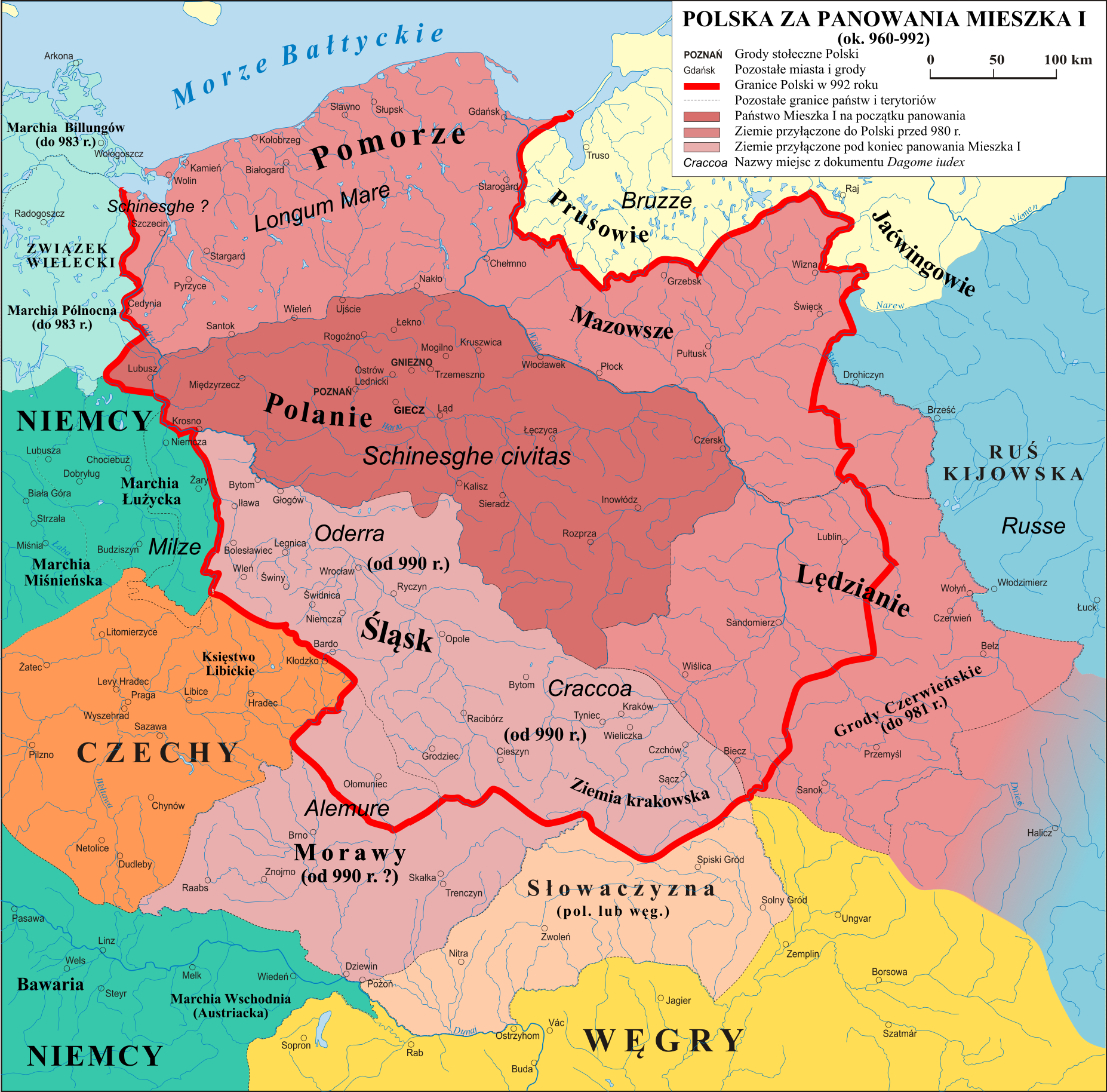
| source | https://upload.wikimedia.org/wikipedia/commons/c/c8/Polska_960_-_992.png |
| warnings:crossing_ways:railway-waterway | 13 |
| warnings:outdated_tags:deprecated_tags | 2 |
Discussion
Ways (18)
- Дністер (24392145), v48
- San (128239341), v9
- Зубра (174994052), v2
- Дністер (181471324), v3
- Дністер (181471328), v2
- Зубра (197271231), v2
- 198554531, v4
- 198556348, v3
- San (198655536), v2
199480340, v2- Дністер (199480341), v2
- Дністер (199480342), v2
- 199480343, v2
- San (199480393), v1
- 199480394, v1
- San (199480395), v1
- Дністер (199480396), v1
- Зубра (199480397), v1
Relations (1-20 of 22)
- 1
- 2
- San (1640410), v15
- Nistru (2474595), v10
- Polska (1951-) (2692126), v54
- Polska (1945-1948) (2692206), v55
- Polska (1948-1951) (2692207), v53
- Україна (1991-2014) (2692220), v47
- Generalgouvernement (1939-1941) (2693083), v25
- Украинская ССР (1954—1991) (2694779), v27
- Украина (1991) (2694780), v27
- Україна (2014-) (2694805), v24
- Украинская ССР (1951—1954) (2694806), v24
- Украинская ССР (1948—1951) (2694807), v23
- Украинская ССР (1945—1948) (2694811), v26
- województwo podkarpackie (2003-) (2695615), v7
- województwo podkarpackie (1999-2003) (2695691), v6
- Deutsches Reich (1940-1941) (2704713), v17
- Deutsches Reich (1940 06-08) (2704714), v19
- Deutsches Reich (1940 05-06) (2704715), v20
- Deutsches Reich (1939-1940) (2704716), v19
- Deutsches Reich (1941 04-08) (2704717), v16
Nodes (1-20 of 718)
Welcome to OpenHistoricalMap!
OpenHistoricalMap is an interactive map of the world throughout history, created by people like you and dedicated to the public domain.
OpenHistoricalMap is a charter project of OpenStreetMap U.S., a 501(c)(3) nonprofit organization affiliated with the OpenStreetMap Foundation. Technical development is supported by GreenInfo Network and Development Seed.
Map Layers
Enable overlays for troubleshooting the map
Map Key
Share
Link or HTML
Geo URI
Image
Only the Standard, Cycle Map and Transport layers can be exported as an image
300 km
100 mi
Range
-
March 22, 1925
mm/dd/yyyy
1/1/1825
1/1/1825
mm/dd/yyyy
12/31/2025
12/31/2025
Time Jump
Speed
| https://openstreetmap.org/copyright | https://openstreetmap.org |
| Copyright OpenHistoricalMap and contributors, under an open license | |