Loading...
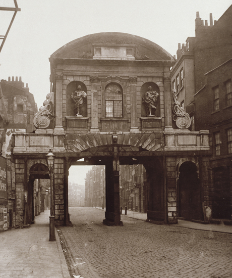
Way: Temple Bar [1672 – 1878] (198661526)
Version #2
London - added buildings, POIs
- Edited by Paul The Archivist
- Changeset #102201
Tags
| building | yes |
|---|---|
| end_date | 1878 |
| end_date:note | Date when building was dismantled, it was re-erected in Theobalds Park, Hertfordshire, and now is in Paternoster Square |
| image:1 | https://upload.wikimedia.org/wikipedia/commons/0/0e/Temple_Bar%2C_London%2C_1878.jpg |
| name | Temple Bar |
| source | Wikipedia;Rocque 1746 map |
| source:1 | OS 1:1056 (1862-74) (NLS) |
| start_date | 1672 |
| start_date:note | Date construction completed for the last Temple Bar building. |
Nodes
7 nodes
- 2093604690
- 2093604689
- 2093604686 (part of way Fleet Street [200 – ] (198588694))
- 2093604688
- 2093604687
- 2093604685 (part of way Strand [200 – ] (198579100))
- 2093604690
Welcome to OpenHistoricalMap!
OpenHistoricalMap is an interactive map of the world throughout history, created by people like you and dedicated to the public domain.
OpenHistoricalMap is a charter project of OpenStreetMap U.S., a 501(c)(3) nonprofit organization affiliated with the OpenStreetMap Foundation. Technical development is supported by GreenInfo Network and Development Seed.
Map Layers
Enable overlays for troubleshooting the map
Map Key
Share
Link or HTML
Geo URI
Image
Only the Standard, Cycle Map and Transport layers can be exported as an image
300 km
100 mi
Range
-
May 1, 1925
mm/dd/yyyy
1/1/1825
1/1/1825
mm/dd/yyyy
12/31/2025
12/31/2025
Time Jump
Speed
| https://www.openhistoricalmap.org/copyright | https://www.openhistoricalmap.org |
| OpenHistoricalMap is dedicated to the public domain except where otherwise noted. | |