Loading...
Way: Aldgate [200 – 1750] (198644311)
Version #1
London - edited London City Wall
- Edited by Paul The Archivist
- Changeset #19969
Tags
| building | gatehouse |
|---|---|
| end_date | 1750 |
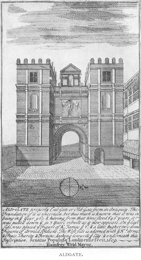
| image:1 | https://upload.wikimedia.org/wikipedia/commons/f/ff/1600_Aldgate.jpg |
| name | Aldgate |
| note | Very rough guess of shape, may not be accurate |
| start_date | 200 |
Nodes
17 nodes
- 2093276645 (part of way London Wall [200 – 1760] (198537195))
- 2093276653 (part of ways [200 – 1760] (198644312) and London Wall [200 – 1760] (198537195))
- 2093276652 (part of way [200 – 1760] (198644312))
- 2093276644
- 2093276643
- 2093276642 (part of way Aldgate [45 – ] (198591726))
- 2093276641
- 2093276640
- 2093276639
- 2093276647 (part of way London Wall [200 – 1760] (198537195))
- 2093276646 (part of way London Wall [200 – 1760] (198537195))
- 2093276638 (part of way London Wall [200 – 1760] (198537195))
- 2093276637 (part of way London Wall [200 – 1760] (198537195))
- Aldgate [200 – 1750] (2091144121) (part of ways Aldgate High Street [45 – ] (198591727), Aldgate [45 – ] (198591726), and London Wall [200 – 1760] (198537195))
- 2093276635 (part of way London Wall [200 – 1760] (198537195))
- 2093276636 (part of way London Wall [200 – 1760] (198537195))
- 2093276645 (part of way London Wall [200 – 1760] (198537195))
Welcome to OpenHistoricalMap!
OpenHistoricalMap is an interactive map of the world throughout history, created by people like you and dedicated to the public domain.
OpenHistoricalMap is a charter project of OpenStreetMap U.S., a 501(c)(3) nonprofit organization affiliated with the OpenStreetMap Foundation. Technical development is supported by GreenInfo Network and Development Seed.
Map Layers
Enable overlays for troubleshooting the map
Map Key
Share
Link or HTML
Geo URI
Image
Only the Standard, Cycle Map and Transport layers can be exported as an image
300 km
100 mi
Range
-
April 7, 1925
mm/dd/yyyy
1/1/1825
1/1/1825
mm/dd/yyyy
12/31/2025
12/31/2025
Time Jump
Speed
| https://openstreetmap.org/copyright | https://openstreetmap.org |
| Copyright OpenHistoricalMap and contributors, under an open license | |