Loading...
Way: 5th (Prospect) Street (198640375)
Version #1
Added street grids of 1788/1797
Tags
| end_date | 1800 |
|---|---|
| highway | unclassified |
| name | 5th (Prospect) Street |
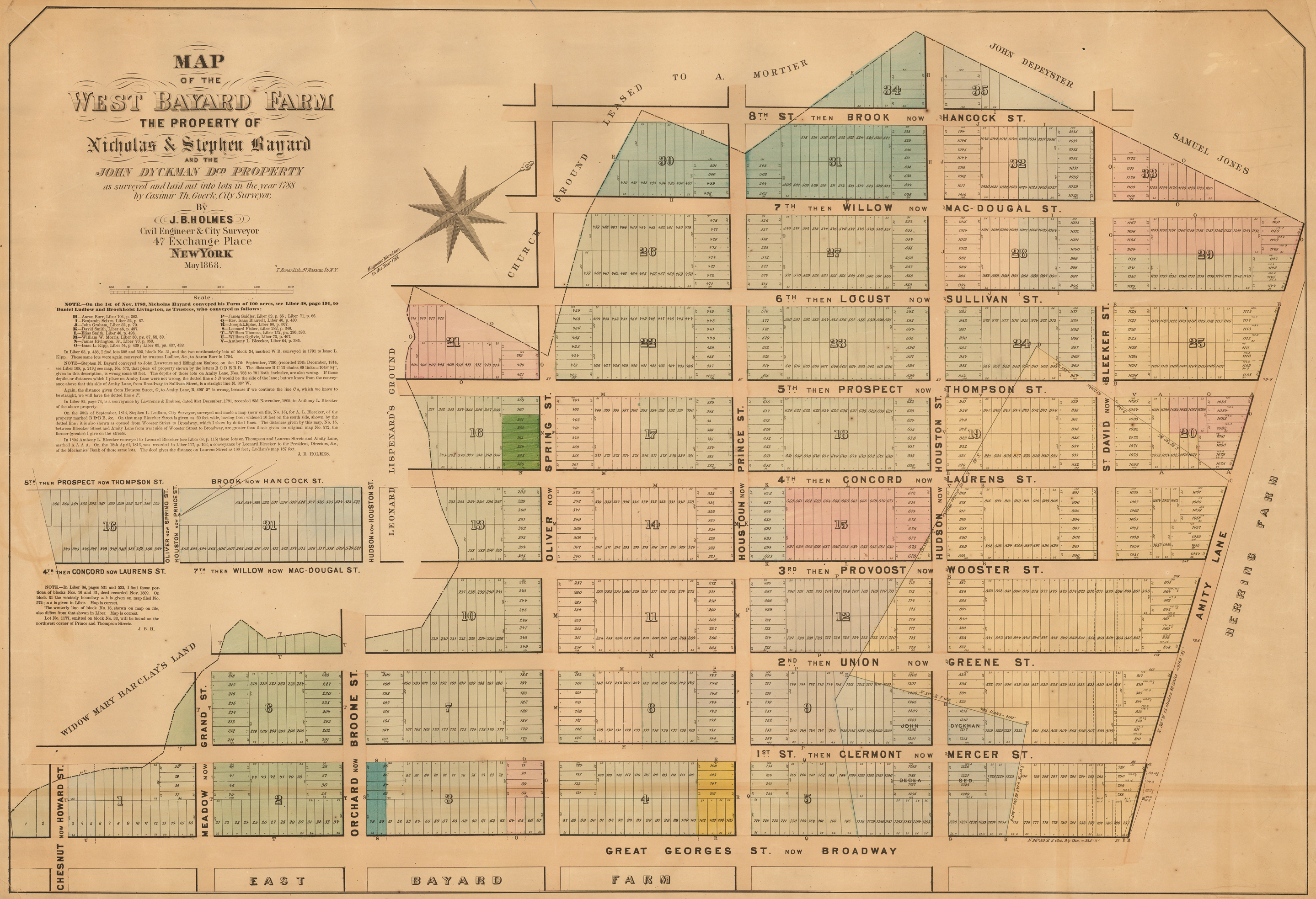
| source | https://upload.wikimedia.org/wikipedia/commons/5/5d/West_Bayard_Farm.jpg |
| source:name | Street Grid of the West Bayard Farm |
| start_date | 1788 |
Nodes
8 nodes
- 2093043590 (part of way Thompson Street (198639918))
- 2093040527 (part of ways Orchard Street (198640366), Broome Street (198640368), and Thompson Street (198639918))
- 2093040528 (part of ways Thompson Street (198639918) and Spring Street (198592960))
- 2093043585 (part of ways Thompson Street (198639918) and Prince Street (198592955))
- 2093043586 (part of ways Thompson Street (198639918) and Houston Street (198761964))
- 2093043587 (part of ways Thompson Street (198639918) and Bleecker Street (198766119))
- 2093043588 (part of way Thompson Street (198639918))
- 2093043591 (part of way Thompson Street (198639918))
Welcome to OpenHistoricalMap!
OpenHistoricalMap is an interactive map of the world throughout history, created by people like you and dedicated to the public domain.
OpenHistoricalMap is a charter project of OpenStreetMap U.S., a 501(c)(3) nonprofit organization affiliated with the OpenStreetMap Foundation. Technical development is supported by GreenInfo Network and Development Seed.
Map Layers
Enable overlays for troubleshooting the map
Map Key
Share
Link or HTML
Geo URI
Image
Only the Standard, Cycle Map and Transport layers can be exported as an image
300 km
100 mi
Range
-
February 13, 1925
mm/dd/yyyy
1/1/1825
1/1/1825
mm/dd/yyyy
12/31/2025
12/31/2025
Time Jump
Speed
| https://openstreetmap.org/copyright | https://openstreetmap.org |
| Copyright OpenHistoricalMap and contributors, under an open license | |