Loading...
Way: Gertrudenstraße [50 – 2022] (198585376)
Unable to contact the OHM server for additional inspector details. Please try again later.
Version #7
Editing
Tags
| end_date | 2022-04 |
|---|---|
| highway | residential |
| name | Gertrudenstraße |
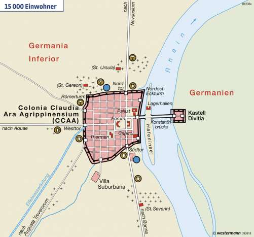
| source | Kölner Stadtplan von 1571;https://media.diercke.net/omeda/501/100267_026_1.jpg |
| start_date | 50 |
Nodes
3 nodes
- 2091199724 (part of ways Breite Straße [1571 – ] (198773639), Gertrudenstraße [2022 – ] (198773642), Breite Straße [1313 – 2022] (198582348), Breite Straße [2022 – ] (198773637), and Römische Straße [50 – 400] (198644774))
- 2093297228 (part of ways Römische Straße [50 – 400] (198644779) and Gertrudenstraße [2022 – ] (198773642))
- 2091794701 (part of ways Gertrudenstraße [50 – ] (198773641) and Gertrudenstraße [2022 – ] (198773642))
Welcome to OpenHistoricalMap!
OpenHistoricalMap is an interactive map of the world throughout history, created by people like you and dedicated to the public domain.
OpenHistoricalMap is a charter project of OpenStreetMap U.S., a 501(c)(3) nonprofit organization affiliated with the OpenStreetMap Foundation. Technical development is supported by GreenInfo Network and Development Seed.
Map Layers
Enable overlays for troubleshooting the map
Map Key
Share
Link or HTML
Geo URI
Image
Only the Standard, Cycle Map and Transport layers can be exported as an image
300 km
100 mi
Range
-
April 16, 1925
mm/dd/yyyy
1/1/1825
1/1/1825
mm/dd/yyyy
12/31/2025
12/31/2025
Time Jump
Speed
| https://www.openhistoricalmap.org/copyright | https://www.openhistoricalmap.org |
| OpenHistoricalMap is dedicated to the public domain except where otherwise noted. | |