Loading...
Relation: Księstwo Polskie (973 - 981) (2744157)
Version #3
Started mapping borders of Duchy of Poland (973-981) - east II
Tags
| boundary | administrative |
|---|---|
| end_date | 0981 |
| name | Księstwo Polskie (973 - 981) |
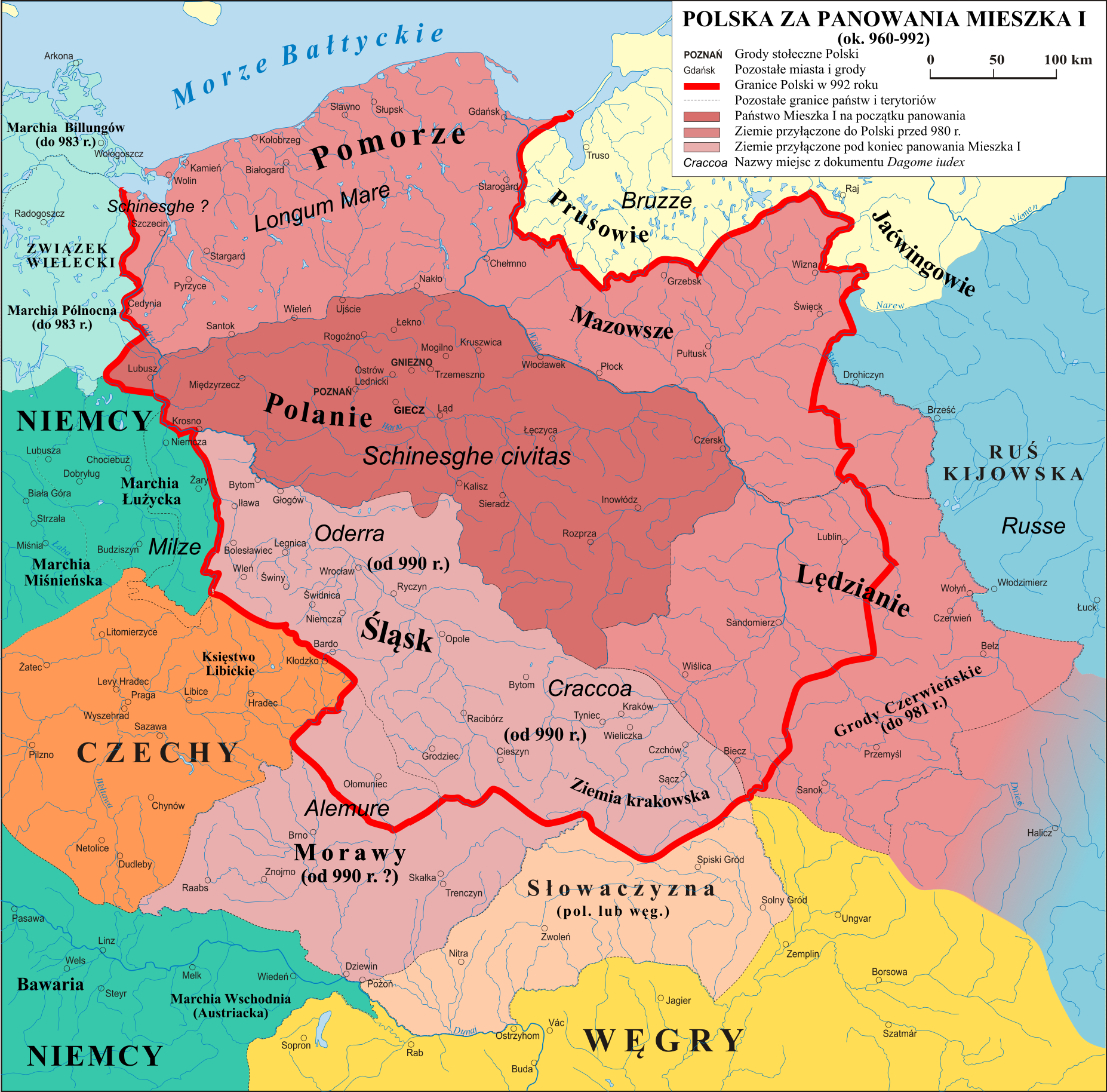
| source | https://upload.wikimedia.org/wikipedia/commons/c/c8/Polska_960_-_992.png |
| start_date | 0973 |
| type | boundary |
Members
50 members
- Way 198591870 as outer
- Way 198564194 as outer
- Way 199475859 as outer
- Way 199475861 as outer
- Way 199475858 as outer
- Way 198636311 as outer
- Way 199475707 as outer
- Way 199475865 as outer
- Way 199475729 as outer
- Way 199475712 as outer
- Way 199475728 as outer
- Way 199475727 as outer
- Way 199475731 as outer
- Way 198595348 as outer
- Way 199475726 as outer
- Way 198592355 as outer
- Way 198592357 as outer
- Way 199382281 as outer
- Way 198728639 as outer
- Way 199382282 as outer
- Way 198722624 as outer
- Way 198577264 as outer
- Way 198577269 as outer
- Way 198746776 as outer
- Way 198543796 as outer
- Way 198746773 as outer
- Way 198556338 as outer
- Way 198587094 as outer
- Way 198746745 as outer
- Way 198746744 as outer
- Way 199480332 as outer
- Way 199480333 as outer
- Way 199480334 as outer
- Way 199480335 as outer
- Way 199480337 as outer
- Way 198556577 as outer
- Way 199416142 as outer
- Way San (119307881) as outer
- Way San (198556672) as outer
- Way San (119307882) as outer
- Way San (199480395) as outer
- Way 199480394 as outer
- Way Дністер (24392145) as outer
- Way Дністер (199480342) as outer
- Way Дністер (187245034) as outer
- Way Дністер (187243139) as outer
- Way Дністер (199480341) as outer
- Way 199480343 as outer
- Way 199480400 as outer
- Way 199480401 as outer
Welcome to OpenHistoricalMap!
OpenHistoricalMap is an interactive map of the world throughout history, created by people like you and dedicated to the public domain.
OpenHistoricalMap is a charter project of OpenStreetMap U.S., a 501(c)(3) nonprofit organization affiliated with the OpenStreetMap Foundation. Technical development is supported by GreenInfo Network and Development Seed.
Map Layers
Enable overlays for troubleshooting the map
Map Key
Share
Link or HTML
Geo URI
Image
Only the Standard, Cycle Map and Transport layers can be exported as an image
| https://openstreetmap.org/copyright | https://openstreetmap.org |
| Copyright OpenHistoricalMap and contributors, under an open license | |