Loading...
Node: Qart Hadasht (2095930362)
Version #4
tag tuning
- Edited by jeffmeyer
- Changeset #36241
- Location: 37.6031690, -0.9812264
Tags
| end_date | -0209 |
|---|---|
| end_date:cause | Conquered by Romans & renamed |
| end_date:source | Wikipedia |
| fixme | lots of tag QA needed; start date; wikipedia |
| followed_by | Carthago Nova |
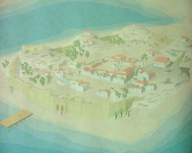
| image:1 | https://www.regmurcia.com/servlet/integra.servlets.Imagenes?METHOD=VERIMAGEN_67990&nombre=RMFOTRecreacionhistoricaQartHadast_res_720.jpg |
| image:1:caption | Plan of Qart Hadast (Recreation) |
| image:1:source | Región de Murcia Digital |
| license | CC0 / public domain |
| name | Qart Hadasht |
| place | city |
| preceded_by | Mastia |
| settlement:era | Paleolithic |
| start_date | -0228 |
| start_date:cause | renamed by Roman general Scipio Africanus after conquering Qart Hadasht from the Carthaginians |
| start_date:source | Wikipedia |
| wikidata | Q162615 |
| wikipedia:en | Cartagena, Spain |
| wof_id | 101748203 |
Welcome to OpenHistoricalMap!
OpenHistoricalMap is an interactive map of the world throughout history, created by people like you and dedicated to the public domain.
OpenHistoricalMap is a charter project of OpenStreetMap U.S., a 501(c)(3) nonprofit organization affiliated with the OpenStreetMap Foundation. Technical development is supported by GreenInfo Network and Development Seed.
Map Layers
Enable overlays for troubleshooting the map
Map Key
Share
Link or HTML
Geo URI
Image
Only the Standard, Cycle Map and Transport layers can be exported as an image
300 km
100 mi
Range
-
March 21, 1925
mm/dd/yyyy
1/1/1825
1/1/1825
mm/dd/yyyy
12/31/2025
12/31/2025
Time Jump
Speed
| https://openstreetmap.org/copyright | https://openstreetmap.org |
| Copyright OpenHistoricalMap and contributors, under an open license | |